Autonomous Mobile Robots (AMRs) have become a cornerstone of modern logistics, healthcare, and research operations. From hospital corridors to pharmaceutical warehouses and biobank repositories, AMRs are transforming how materials move, efficiently, reliably, and without direct human intervention. Yet, one of the most subtle and persistent challenges they face lies not in the complexity of their tasks but in the simplicity of their surroundings. Welcome to the paradox of homogeneous environments, spaces so uniform and featureless that even the smartest robots can lose their sense of direction.
Hallway Blindness
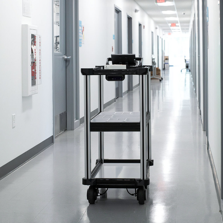
Imagine walking down a long, identical corridor with no windows, artwork, or signs, just white walls, uniform lighting, and a polished floor that stretches endlessly in both directions. Now imagine trying to find your way back without a map or GPS signal. For most people, disorientation would set in quickly. AMRs face the same problem.
Hospitals, laboratory wings, and biobank facilities are classic examples of homogeneous environments. In a hospital, long hallways lined with identical doors create a visual landscape devoid of distinctive features. In a biobank, rows of identical -80°C freezers extend through climate-controlled rooms, each looking nearly identical to the others from the robot’s perspective. Even the reflections on the floor or glossy surfaces can make localization more difficult by confusing the sensors. For humans, visual cues like color, signage, or memory help correct our sense of position. For AMRs, localization relies on LiDAR scans, depth cameras, and map-based inference. When every scan looks the same, positional certainty drops, and navigation accuracy suffers.
Why Homogeneity Confuses AMRs
Modern AMRs like Quasi Robotics’ Model C2 use simultaneous localization and mapping (SLAM) algorithms to navigate. These systems build a 3D map of their surroundings using LiDAR and camera data, constantly comparing what the robot “sees” to its internal model of the world. The problem? SLAM
thrives on variety. When surfaces, shapes, and patterns repeat endlessly, the algorithm has little data to anchor its position. In practical terms, this can lead to:
- Drift over distance: Small errors in localization accumulate as the robot moves through featureless space.
- Misalignment of waypoints: The robot may believe it’s a few centimeters or even meters away from its true position.
- Navigation failure: In extreme cases, the AMR can “lose” itself entirely, halting operations until it reacquires orientation. These issues don’t indicate a flaw in the robot; they’re inherent to the
physics of perception. Just as a human might walk in circles in a whiteout snowstorm, an AMR can lose track in a corridor where every scan looks identical.
The Human Analogy: When Robots Get “Lost”
It helps to think of AMRs as a bit like humans. We use landmarks, patterns, and spatial memory to navigate. Remove those, and confusion follows. Robots experience a similar cognitive gap, but without the intuition to “guess” their position.
That’s why Quasi Robotics designs its systems to think more like people learning from past routes, recognizing stable reference points, and fusing multiple sensor inputs for redundancy. Still, even with advanced AI and mapping algorithms, some environments require additional help.
Model C2: Designed to Navigate the Hardest Spaces
The Model C2 Autonomous Mobile Robotic Cart was built to operate in complex indoor facilities, from hospitals and laboratories to manufacturing floors and warehouses. Its localization algorithms use advanced sensor fusion, combining LiDAR, time-of-flight (ToF) cameras, odometry, and machine vision for robust navigation.
However, as outlined in the Model C2’s Limitations of Use document, homogeneous environments present a unique edge case. In such settings, “supplemental localization aids such as AprilTags, a permanently affixed visual QR code on walls, are used to ensure reliable navigation and mapping.”
These aids act as fixed reference points, giving the robot a way to verify its position even when the surroundings appear identical.
AprilTags: A Simple but Powerful Solution
AprilTags are small, high-contrast visual markers that function much like QR codes but are optimized for robotic vision. They can be printed on standard paper, placed strategically around the facility, and recognized by the AMRs’ onboard depth camera.
When the Model C2 encounters an AprilTag during mapping or navigation, it immediately recognizes the tag’s unique ID and cross-references its exact known position on the map. This process effectively “resets” the robot’s location certainty, just like a human glancing at a street sign to confirm where they are.
This is especially critical for large facilities with extremely long corridors or repetitive layouts, where small localization errors could otherwise accumulate into major misalignments.
Implementing AprilTags in Your Facility
Setting up AprilTags in a homogeneous environment is straightforward:
Generate Tags:
Visit https://chev.me/arucogen/ and select the dictionary code “AprilTag 25h9 (35)”. Keep the marker size at 100mm with scaling enabled when printing.
Number of Tags:
You can print up to 34 unique AprilTags, each with a different ID number.
Placement:
- Mount tags at approximately the same height as the C2’s front-facing camera (a few inches above or below is fine).
- Avoid laminating or placing the tag behind glossy or reflective covers, as these can distort the camera’s perception.
- Position them at regular intervals along long corridors, at key intersections, or near important waypoints.
Finally, Remap the Facility:
A clean re-map is required after installing tags. The C2 learns tag positions during mapping, creating a stable, permanent grid reference for future operations. Once in place, these AprilTags drastically enhance navigation reliability, ensuring consistent, repeatable routes even in the most visually monotonous environments.
Beyond AprilTags: The Future of AMR Localization
While AprilTags offer a practical fix today, Quasi Robotics is continuously advancing localization algorithms to reduce reliance on external markers. The Model C2’s architecture allows for future over-the-air updates that improve perception through enhanced AI-based SLAM, multi-sensor fusion,
and semantic mapping, teaching the robot to recognize patterns humans take for granted, such as doorways, light fixtures, or subtle floor variations. Still, even as technology evolves, environmental factors will always play a role in performance. Understanding these challenges and addressing them with simple tools like AprilTags can make the difference between smooth automation and repeated downtime.
A Shared Sense of Direction
Ultimately, the challenges AMRs face in homogeneous environments remind us of something deeply human: orientation is context. Whether we’re walking through a maze-like hospital or a robot is navigating a row of identical freezers, we both rely on landmarks to find our way. Quasi Robotics’ mission with the Model C2 is to ensure that our robots can handle both the complex and the deceptively simple, maintaining precision, safety, and confidence wherever they go. Through thoughtful design,
intelligent mapping, and smart use of tools like AprilTags, we’re helping robots see the world with greater clarity, and helping facilities operate with greater reliability.
About Quasi Robotics
Quasi Robotics designs and manufactures intelligent autonomous mobile robots (AMRs) that bring precision and efficiency to industrial and healthcare environments. The company’s flagship Model C2 AMR Cart is built for self-loading, autonomous elevator navigation, and advanced facility integration.
Learn more at: https://www.quasi.ai/
Visit us on LinkedIn: https://www.linkedin.com/company/quasi-robotics/